Showing 5 items matching local government area - kew - victoria
-
 Kew Historical Society Inc
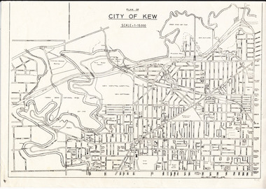
Plan, City of Kew, 1979
... local government area - kew - victoria... government area - kew - victoria cartography City of Kew ...Plan of the City of Kew produced for public distributionPlan of City of Kew - Scale 1 : 15000Revised June 1979plans - city of kew (vic.), maps - kew (vic.), local government area - kew - victoria, cartography -
![Governing the Metropolis: politics, technology and social change in a Victorian city - Melbourne, 1850-1891 / [by] David Dunstan](https://victoriancollections.net.au/media/collectors/550653872162f11fb04854aa/items/5ed0413cdcf9cd08346b6448/item-media/5ed04231dcf9cd08346b66f5/item-fit-380x285.jpg) Kew Historical Society Inc
Kew Historical Society IncBook, Melbourne University Press, Governing the Metropolis: politics, technology and social change in a Victorian city - Melbourne, 1850-1891, 1984
Carlton, Vic. : Melbourne University Press, 1984 xvii, 362 p., [14] p. of plates : ill., facsims., maps, ports. ; 24 cm. non-fictionmelbourne metropolitan area (vic) -- politics and government -- 1851-1891., urbanization -- victoria -- melbourne. -
 Kew Historical Society Inc
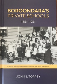
Book, John L Torpey, Boroondara's Private Schools 1851-1951: a century of non-government education in the City of Boroondara, 2021
History of education and past and present non-government schools in the local government area of the City of Boroondara (1994- ). Before 1994, the schools were located in the former municipalities of Camberwell, Hawthorn, Kew et al.Foreword [L M Ling]. Preface. Education in Victoria. Why did some schools fail and others thrive? Victorian Private Schools. Adopting the character and culture of the British Public School. Some of the key players. Past schools. The Survivors. Conclusions. Appendices. Notes. Bibliography. Acknowledgements. Index. [194 pp]non-fictionHistory of education and past and present non-government schools in the local government area of the City of Boroondara (1994- ). Before 1994, the schools were located in the former municipalities of Camberwell, Hawthorn, Kew et al.education -- boroondara, schools -- history -- camberwell, schools -- history -- hawthorn, schools -- history -- kew, private schools -- boroondara (vic.) -
 Kew Historical Society Inc
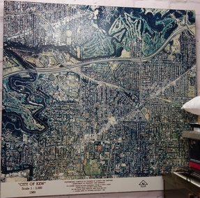
Photograph - Aerial Photograph, Division of Survey and Mapping, Department of Property and Services, City of Kew, Scale 1 : 3,000, 1989
The City of Kew was a local government area about 4 kilometres east of Melbourne, the state capital of Victoria, Australia, on the southeast bank of the Yarra River. The city covered an area of 14.56 square kilometres, and existed from 1860 until 1994.Very large aerial photograph of “City of Kew” Scale 1 : 3,000. 1989. “City of Kew” Scale 1 : 3,000. 1989. Photomosaic compiled by Division of Survey and Mapping, Department of Property and Services. © Crown (State of Victoria) Copyright 1990.city of kew, kew (vic.), aerial photography -
 Kew Historical Society Inc
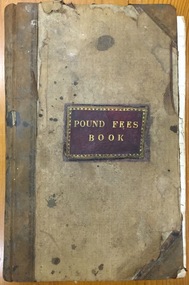
Administrative record (item), Borough of Kew, Pound Fees Book, 1874-1896
While the first successful land sales in Boroondara occurred in Hawthorn in 1843, and Kew in 1845, these areas were to be without local pounds until April 1858, when the Governor of Victoria, in accordance with Act 18 Victoria No 30, was pleased to direct the establishment of a Pound at Glass’s Creek on that part of land bounded by the Kilby Road, Burke Road and High Street. While the Governor was required to proclaim the establishment of a pound, the appointment of a poundkeeper was the responsibility of the Justices of the Peace in the local Court of Petty Sessions. The Pound took its name from the most distinctive natural feature of the area, Glass’s Creek, named after the early pastoralist Thomas Glass.The register is of historic significance as an indicator of suburban life in the second half of the 19th Century. It shows how farming and city life on the urban fringe were intimately connected. It is also significant to the early history of Hawthorn and Kew, who both claimed the Pound following their separation from the Boroondara Roads Board in 1861."Kew Pound Book"glass creek pound (kew), animal pound, dog pound, kew pound, j. smith, john oakes, samuel b. cash, edward s. delaney, emma oswin, samuel cash